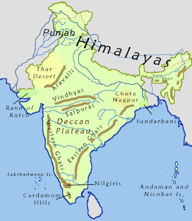
Physical Geography of INDIA
The Great Northern Plains
This fertile plain lies to the south of the
northern mountains. This plain is one of the
most extensive stretches of the alluvium in
the world and is deposited by the rivers Indus,
Ganga, Brahmaputra and their tributaries. The
length of the plain is about 2,400 km and the
width varies from 240 to 320 km. Its width
increases from east to west. It covers an area of
over 7 lakh sq.km.
The Great Plains of India is remarkably a
homogeneous surface with an imperceptible
slope. They are formed mostly by the depositional
process of the Himalayan and Vindhyan rivers.
These rivers deposit enormous quantity of
sediments deposited along the foothills and
flood plains. The important characteristics
featuress of sediment deposition in the plains
areas as follows.
- a) The Bhabar Plain
- b) The Tarai Tract
- c) The Bhangar Plains
- d) The Khadar Plains
- e) Delta
a) The Bhabar Plain
This plain is made up of gravels and
unassorted sediments deposited by the
Himalayan rivers. The porosity of this plain is
so high that most of the small streams flow over
this region disappear. Its width varies from
8 to 15 km. It is wider in the western plains
(Jammu Division) than in the east (Assam).
This plain is not suitable for cultivation, only big
trees with large roots thrive in this region.
b) The Tarai Tract
It is a zone of excessive dampness, thick
forests and rich wild life. This tract lies to the
south of Bhabar plains. The width of this belt
is 15-30 km. The Tarai is wider in the eastern parts
of the Great Plains, especially in Brahmaputra
Valley due to heavy rainfall. In many states, the
Tarai forests have been cleared for cultivation.
c) The Bhangar Plains
The Bhangar represent the upland alluvial
tracts of the Great Plains of India, formed by the
older alluviums. The Bhangar land lies above
the flood limits of the rivers. This soil is dark in
colour, rich in humus content, well drained and
useful for agriculture.
d) The Khadar Plains
The new alluvium tracts along the courses
of the rivers are known as the ‘Khadar’ or ‘Bet’
lands. The Khadar tracts are enriched by fresh
deposits of silt every year during rainy seasons.
The Khadar land consists of sand, silt, clay and
mud. It is highly fertile soil.
e) Delta
Triangle shaped fertile land at the mouth
of Ganga and Brahmaputhra rivers is called as
the Sundarban delta. It is the biggest and fastest
growing delta. It is an area of deposition as the
river flows in this tract sluggishly. The deltaic
plain consists mainly of old mud, new mud
and marsh. In the delta region, the uplands are
called ‘Chars’ while the marshy areas are called
‘Bils’.
On the basis of deposition of sediments by
various rivers and topographical characteristics,
the Northern Plains of India is divided into the
following four major regions:
1) Rajasthan Plains:
It is located to
the west of Aravalli range. It covers
an area of about 1,75,000 sq.km.
Rajasthan plain is formed by the deposition
of the river Luni and the long vanished river
Saraswathi. There are several salt lakes in
Rajasthan. The Sambhar salt lake (Pushkar
Lake) near Jaipur is the prominent one.
The Thar desert, also known as the Great
Indian desert is a large arid region in the
north western part of the Indian subcontinent
that covers an area of 2,00,000 km2
and
forms a natural boundary between India and
Pakistan. It is the world 7th largest desert.
The desert lies in the western part of the
aravalli range and covers 2/3 of Rajastan
state. There are two major divisions in the
Thar desert. They are known as the Actual
desert region (Marusthali) and the semi
desert region (Bhangar). Many different
types of sand dunes and salt lakes (Dhands)
are seen here.
2) Punjab - Haryana Plains:
It lies to the northeast of the Great Indian Desert. This plain is
found over an area of about 1.75 lakh sq.km.
The Punjab - Haryana plains are formed by
the deposition of the rivers Sutlej, Beas and
Ravi. This plain acts as water - divide (doab).
The two major watershed it divides are
Yamuna – Sutlej and Ganga – Yamuna.
3) Ganga Plains:
It extends from the Yamuna
River in the west to Bangladesh in the east.
The total area covered by this plain is about
3.75 sq.km. River Ganga and its tributaries
such as Ghaghra, Gandak, Kosi, Yamuna,
Chambal, Betwa etc. constitute this plain
by their sediments and make a great plain
in India. It is the largest plain of India. The
general slope of the entire plain (upper,
middle and lower Ganga plains) is towards
east and south-east.
4) Brahmaputra Plains:
It is located mainly
in the state of Assam. It is a low - level plain
located in the eastern part of the Great Plains
of India and is formed by the deposits of
river Brahmaputra. It covers an area of about
56,275 sq.km. These plains create alluvial
fans and marshy tracts.
The Peninsular Plateaus
The plateau region lies to the south of
the Great Northern Plains. This is the largest
physiographic division of our country.
It covers an area of about 16 lakh sq.km (about
half of the total area of the country). It is an old
rocky plateau region. The topography consists of
a series of plateaus and hill ranges interspersed
with river valleys.
Aravalli hills mark the north-western
boundary of the plateau region. Its northern
and north-eastern boundaries are marked by
the Bundelkhand upland, Kaimur and Rajmahal
hills. The Western Ghats and the Eastern Ghats
mark the western and eastern boundaries
respectively. The altitude of a large portion of
the plateau is more than 600 m from mean sea
level. The peak of Anaimudi is the highest
point in the plateau. Its height is 2,695 m and is located in Anaimalai. The general slope of
this plateau is towards east. The Great Plateau
is a part of the Gondwana (very ancient one)
land mass. Due to the old age, the rivers in this
region attained their base level and developed
broad and shallow valleys.
The river Narmada divides the plateau
region of India broadly into two parts. The
region lying to the north of the Narmada is
called the Central Highlands and the region
lying to the south of Narmada is called the
Deccan Plateau. All the major rivers (Mahanadi,
Godavari, Krishna, Kaveri etc.) lying to the
south of the Vindhyas flow eastwards and fall
into the Bay of Bengal. Narmada and Tapti
are the two rivers situated to the south of the
Vindhyas flow westward. Their movement
towards west is due to the presence of
a rift valley in the region.
a) Central Highlands
The Central Highlands extend between the
river Narmada and the Northern Great Plains.
The Aravallis form the west and northwestern
edge of the Central Highlands. These hills extend
from Gujarat, through Rajasthan to Delhi in the
northwesterly direction for a distance of about
700 km. The height of these hills is about 1,500 m
in southwest while near Delhi the height is
hardly 400 m. Gurushikhar with 1,722 m is the
highest peak of this range.
The Western part of the Central Highland
is known as the Malwa Plateau. It lies to the
southeast of Aravallis and to the north of
Vindhyachal Range. The rivers Chambal, Betwa
and Ken drain the Malwa Plateau before they
join the river Yamuna. The part of the Central
Highlands which extends to the east of Malwa
Plateau is known as Bundelkhand and its
further extension is known as Bagelkhand. The
eastern part of the Central High lands which
lies in the north-eastern part of the Indian
Plateau is known as Chhota-Nagpur Plateau.
It covers much of Jharkhand, adjacent parts of
Odisha, West Bengal, Bihar and Chhattisgarh.
This region is very rich in mineral resources
particularly iron ore and coal.
b) Deccan Plateau
This physiographic division is the largest
part of the plateau region of India. The shape
of this plateau is roughly triangular. One of
the sides of this triangle is marked by the line
joining Kanyakumari with Rajmahal Hills and
this line passes through the Eastern Ghats. The
second arm is marked by the Satpura Range,
Mahadeo Hills, Maikal Range and the Rajmahal
Hills. The third arm is marked by the Western
Ghats. The area of this Plateau is about 7 lakh
square km and the height ranges from 500 to
1000 m above sea level.
1. The Western Ghats
The Western Ghats forms the western
edge of the Peninsular Plateau. It runs parallel
to the Arabian Sea coast. The northern part of
this range is called as Sahyadris. The height of
the Sahyadris increases from north to south.
Anaimudi is a sort of tri-junction of the
Anaimalai Range, the Cardamom Hills and the
Palani Hills. Kodaikanal is a beautiful hill resort
situated on the Palani Hills.
2. The Eastern Ghats
Eastern Ghats run from southwest to
northeast form the eastern edge of this Plateau.
This range is also called as Poorvadri. The
Eastern Ghats join the Western Ghats at the
Nilgiri hills, bordering Karnataka and Tamil
Nadu. The Eastern Ghats are not continuous
like the Western Ghats. The rivers of Mahanadi,
Godavari, Krishna, Pennar and Kaveri have
dissected this range at many places.
The Coastal Plains
The Peninsula Plateau of India is flanked
by narrow coastal plains of varied width
from north to south. They were formed by
the depositional action of the rivers and the
erosional and depositional actions of the seawaves. The Indian coastal plains are divided
into the following two divisions:
1) The Western Coastal Plains
2) The Eastern Coastal Plains.
1. The Western Coastal Plain
It lies between the Western Ghats and the
Arabian Sea. It extends from Rann of kutch
in the north to Kanyakumari in the south and
its width varies from 10 to 80 km. It is mainly
characterised by sandy beaches, coastal sand
dunes, mud flats, lagoons, estuary, laterite
platforms and residual hills. The northern part
of the West Coastal Plain is known as Konkan
Plain. The middle part of this plain is known
as Kanara. The southern part of the plain is
known as Malabar coast which is about 550
km long and 20-100 km wide. This part of the
coast is characterized by sand dunes. Along the
coast, there are numerous shallow lagoons and
backwaters called Kayals and Teris. Vembanad
is a famous back water lake found in this region.
2. The Eastern Coastal Plain
It lies between the Eastern Ghats and the
Bay of Bengal and, stretches along the states
of West Bengal, Odisha, Andhra Pradesh
and Tamil Nadu. These plains are formed by
the alluvial fillings of the littoral zone by the
east flowing rivers of India. The coastal plain
consists mainly of the recent alluvial deposits.
This coastal plain has a regular shoreline with
well-defined beaches. The coastal plain between
Mahanadi and Krishna river is known as the
Northern Circars and the southern part lies
between Krishna and Kaveri rivers is called
Coromandal coast. Among the back water lakes
of this coast, lake Chilka (Odisha) is the largest
lake in India located to the southwest of the
Mahanadi delta, the Kolleru Lake which lies
between the deltas of Godavari and Krishna and
the Pulicat Lake lies in the border of Andhra
Pradesh and Tamil Nadu are the well known
lakes in the east coastal plain.
The Islands
India has two major island groups namely
Andaman and Nicobar and Lakshadweep. The
former group consists of 572 islands and are
located in Bay of Bengal, and the later one has
27 islands and are located in Arabian Sea. The
islands of Andaman and Nicobar are largely tectonic and volcanic origin. India’s only active
volcano is found on Barren Island in Andaman
and Nicobar group of Islands.
a) Andaman and Nicobar Islands
These islands are located in an elevated
portion of the submarine mountains. Since
these islands lie close to the equator, the climate
remains hot and wet throughout the year and
has dense forests. The area of the island group is
about 8,249 sq.km. The entire group of islands
is divided into two. They are Andaman in the
north and the Nicobar in the south. These
island groups are of great strategic importance
for the country. Port Blair is the administrative
capital of the Andaman and Nicobar islands.
The Ten Degree Channel separates Andaman
from Nicobar group. The southernmost tip, the
Indira Point is a part of Nicobar Island.
b) Lakshadweep Islands
This is a small group of coral islands located
off the west coast of India. It covers an area of
32 sq. km. Kavaratti is its administrative capital.
Lakshadweep islands are separated from the
Maldive Islands by the Eight Degree Channel.
The uninhabited “Pitt Island” of this group has
a bird sanctuary. Earlier, it had three divisions
namely Laccadive, Minicoy and Amindivi. It
was named as Lakshadweep in 1973.
c) Offshore Islands
Besides the two group of islands, India has
a number of islands along the Western Coast,
Eastern Coast, in the delta region of Ganga and
in the Gulf of Mannar. Many of these islands
are uninhabited and are administered by the
adjacent states.
"This Content Sponsored by Buymote Shopping app
BuyMote E-Shopping Application is One of the Online Shopping App
Now Available on Play Store & App Store (Buymote E-Shopping)
Click Below Link and Install Application: https://buymote.shop/links/0f5993744a9213079a6b53e8
Sponsor Content: #buymote #buymoteeshopping #buymoteonline #buymoteshopping #buymoteapplication"


Comments
Post a Comment